BANGKOK, Thailand – Following the recent flooding in Mae Sai, Chiang Rai, a former member of the 13 Wild Boars rescue team, Folk Kamponsak Sassadee, has clarified on Sep 13 that the flooding was not caused by deforestation within Thailand but primarily resulted from factors in neighboring countries.
On September 12, after water levels had started to recede, heavy rain caused the levels to rise again, inundating buildings, businesses, and communities such as Huai Fai, Sai Lom Joy, Ko Sai, Mai Lung Khon, and Mueang Daeng. Many residents remain stranded as access is severely restricted.
In his Facebook post, Folk Kamponsak Sassadee, who was involved in the Tham Luang cave rescue operation, addressed the flooding’s origins. He explained:
“The floods in Mae Sai are not due to deforestation in Thailand. The massive volume of water inundating Mae Sai largely originates from Myanmar. This water starts from high mountain areas in Myanmar, which are drained through various tributaries into the Mae Sai River, marking the border area in Mae Sai. The river then winds its way about 50 kilometers before joining the Mekong River at the Golden Triangle.
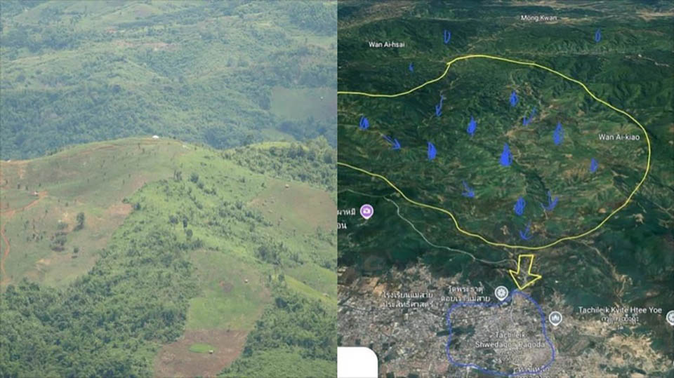
In the upstream areas of Myanmar, there are almost no remaining original forests. The soil has been cleared for agriculture for decades, and repeated burning has degraded the land. Large forests, once abundant, have been cut down and processed for over a century. New growth mainly consists of bamboo and small shrubbery.
Rice fields, including terraced rice paddies, are common in the riverbank areas since there is little flat land for farming compared to Thailand.
During monsoon seasons, the lack of forest cover means that massive amounts of mud and water flow rapidly downhill without being absorbed or slowed by forest systems.
Addressing the issue of upstream forest degradation in Myanmar is challenging as it involves long-standing land use practices. The volume of seasonal water may increase in future years, potentially causing more severe flooding.
To mitigate future flooding in Mae Sai, Folk proposed building a continuous flood wall along the riverbank, starting from the base of Wat Tham Phajom and extending to the Mae Sai border checkpoint 2. The wall would need to be designed to the height necessary based on this year’s flood levels. This would be approximately 10 kilometers long on the Thai side, with the Myanmar side also needing to develop its own flood management plans.
This flood wall proposal is Folk’s personal idea and might require substantial funding, potentially billions of baht, if implemented. Photographs of Myanmar’s flood-prone areas from July last year highlight the severity of the issue.”
Photographs from July last year, taken near the border road around Phahmi, Phahi, and Doi Chang Mup areas in Myanmar, illustrate the severe flooding conditions in the region. These images underscore the impact of water flow from upstream areas in Myanmar, which significantly contributes to the flooding experienced in Mae Sai, Chiang Rai.


