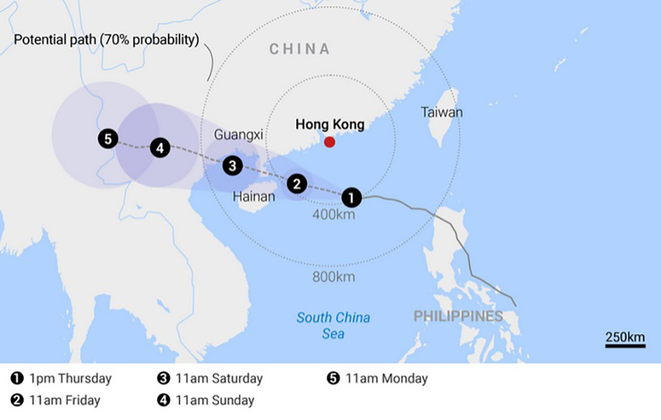
BANGKOK, Thailand – The North and Northeast regions are being advised to brace for isolated heavy rains this weekend, September 7-8, as tropical storm Yagi strengthens into a typhoon. The Thai Meteorological Department has warned that the storm, currently over the upper South China Sea, is expected to intensify as it moves toward Hainan, China, before making landfall in upper Vietnam on Friday or Saturday, September 6-7.
It will weaken after landfall but is still forecast to bring heavy rainfall to parts of Thailand.
The storm’s impact will coincide with the presence of a moderate monsoon trough and a strong southwest monsoon over the Andaman Sea, the South, and the Gulf of Thailand.
From August 4-6, these weather patterns are expected to bring heavy rains to the lower North, Central, and Northeast regions, with very heavy rains possible along the east and west coasts.
Residents in affected areas, especially those living near foothills, waterways, and low-lying areas, are urged to be vigilant for potential flash floods and overflowing rivers due to rain accumulation.
Authorities have advised that residents take precautions as the storm progresses.
Maritime conditions will also be hazardous, with waves in the Andaman Sea and the upper Gulf reaching up to 3 meters and even higher during thundershowers. All ships are urged to proceed with extreme caution, and small boats should remain ashore until the weather improves.
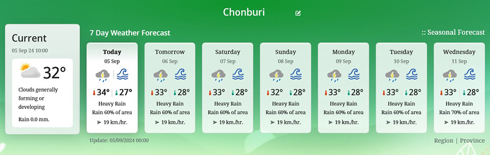
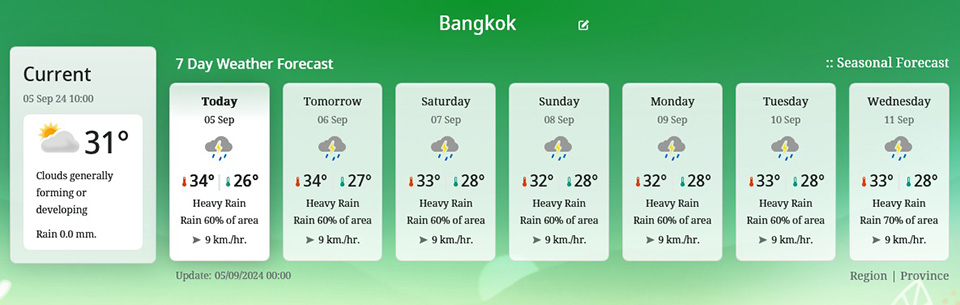
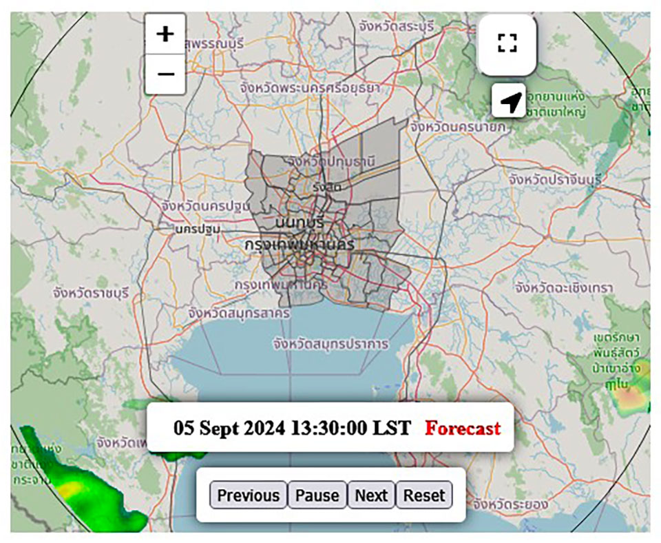
Bangkok and Metropolitan Region: Expect thunderstorms covering 60% of the area. The temperature will range from a low of 25-27°C to a high of 33-35°C, with southwest winds blowing at speeds of 10-25 km/h.
Northern Region: Thunderstorms are predicted for 40% of the area, with heavy rain in some places, especially in Nan, Tak, and Phetchabun provinces. Temperatures will range from 23-26°C to 33-36°C, and southwest winds will reach speeds of 10-20 km/h.
Northeastern Region: Thunderstorms will cover 40% of the area, with some heavy rainfall expected in Nakhon Phanom, Mukdahan, Yasothon, Amnat Charoen, Nakhon Ratchasima, and Ubon Ratchathani. The temperature will range from 23-26°C to 33-35°C, with southwest winds blowing at 10-20 km/h.
Central Region: Thunderstorms are forecasted for 60% of the area, with heavy rain expected in Uthai Thani, Lopburi, Saraburi, and Kanchanaburi. The temperature will range from 24-26°C to 34-35°C, and southwest winds will blow at 10-25 km/h.
Eastern Region: Thunderstorms will cover 70% of the area, with heavy rainfall expected in Nakhon Nayok, Prachinburi, Chanthaburi, and Trat provinces. Temperatures will range from 24-27°C to 30-34°C. Southwest winds will reach 20-40 km/h, and the sea will have waves 2-3 meters high, rising to over 3 meters in areas with thunderstorms.
Southern Region (East Coast): Thunderstorms are forecasted for 60% of the area, mainly in Phetchaburi, Prachuap Khiri Khan, Chumphon, and Surat Thani. Temperatures will range from 24-26°C to 33-35°C. For areas north of Surat Thani, southwest winds will blow at 20-35 km/h, with sea waves around 2 meters, rising higher in thunderstorm areas. South of Nakhon Si Thammarat, winds will reach 15-35 km/h, with waves of 1-2 meters, rising in areas with thunderstorms.
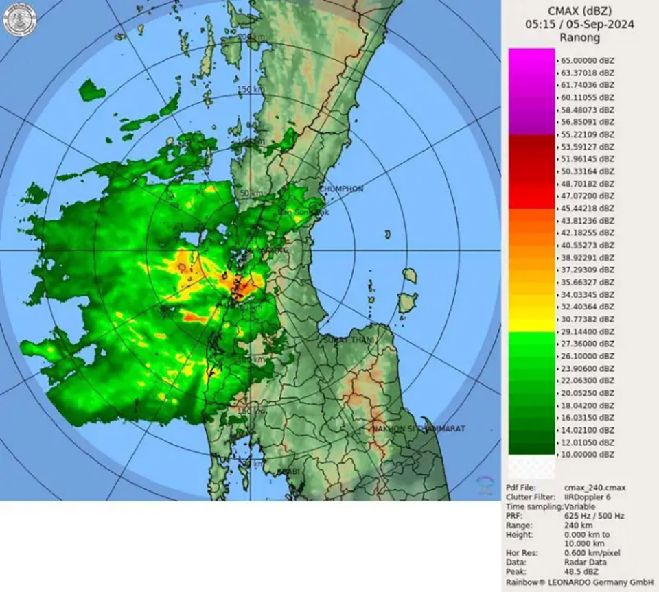
Southern Region (West Coast): Thunderstorms are predicted for 70% of the area, with heavy rainfall in Ranong, Phang Nga, and Phuket. Temperatures will range from 24-26°C to 31-33°C, with southwest winds blowing at 20-40 km/h. The sea will have waves 2-3 meters high, increasing to over 3 meters in areas with thunderstorms.


