BANGKOK, Thailand – The Meteorological Department has issued its 12th official warning regarding Tropical Storm “Soulik,” which has now weakened into a tropical depression. As of 4:00 AM on September 20, the storm’s center was located in Khammouane Province, Laos, approximately 100 kilometers northeast of Nakhon Phanom, Thailand. With maximum sustained winds near the storm’s center at 55 kilometers per hour, “Soulik” is moving slowly northward and is expected to further weaken into a low-pressure system.
Impact on Thailand: Heavy Rain and Strong Winds
The effects of the tropical depression will bring heavy to very heavy rainfall and strong winds to several regions across Thailand, including the North, Northeast, Central, Eastern, and Southern regions, as well as the Bangkok Metropolitan Area. The Meteorological Department urges residents in these regions to be cautious of flash floods, sudden water surges, and landslides, particularly in hilly and low-lying areas.
Regions and Provinces Expected to Be Affected
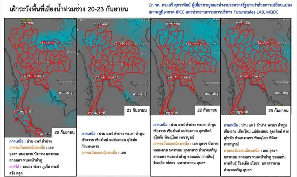
On September 20:
Northern Region: Chiang Mai, Lampang, Lamphun, Phayao, Nan, Phrae, Sukhothai, Uttaradit, Tak, Phitsanulok, and Phetchabun.
Northeastern Region: Loei, Nong Khai, Bueng Kan, Nong Bua Lam Phu, Udon Thani, Sakon Nakhon, Nakhon Phanom, Chaiyaphum, Khon Kaen, Maha Sarakham, Kalasin, Mukdahan, Roi Et, Yasothon, Amnat Charoen, Surin, Si Sa Ket, and Ubon Ratchathani.
Central Region: Nakhon Sawan, Sing Buri, Ang Thong, Lop Buri, Saraburi, and Ayutthaya.
Eastern Region: Nakhon Nayok, Prachin Buri, Sa Kaeo, Rayong, Chanthaburi, and Trat.
Southern Region: Phetchaburi, Prachuap Khiri Khan, Chumphon, Surat Thani, Nakhon Si Thammarat, Phatthalung, Songkhla, Ranong, Phang Nga, Phuket, Krabi, Trang, and Satun.
On September 21:
Northern Region: Mae Hong Son, Chiang Mai, Chiang Rai, Lamphun, Lampang, Phayao, Nan, Phrae, Uttaradit, Tak, Sukhothai, Kamphaeng Phet, Phichit, Phitsanulok, and Phetchabun.
Northeastern Region: Loei, Nong Khai, Bueng Kan, Nong Bua Lam Phu, Udon Thani, Sakon Nakhon, Nakhon Phanom, Chaiyaphum, Khon Kaen, Maha Sarakham, and Nakhon Ratchasima.
Central Region: Nakhon Sawan, Uthai Thani, Chai Nat, Lop Buri, Saraburi, Kanchanaburi, Ratchaburi, and Greater Bangkok (including surrounding provinces).
Eastern Region: Nakhon Nayok, Prachin Buri, Sa Kaeo, Chachoengsao, Chon Buri (Pattaya), Rayong, Chanthaburi, and Trat.
Southern Region: Phetchaburi, Prachuap Khiri Khan, Chumphon, Surat Thani, Ranong, Phang Nga, Phuket, and Krabi.

On September 22-23:
Northern Region: Mae Hong Son, Chiang Mai, Chiang Rai, Lamphun, Lampang, Phayao, Nan, Phrae, Uttaradit, Tak, Sukhothai, Kamphaeng Phet, Phichit, Phitsanulok, and Phetchabun.
Northeastern Region: Loei, Nong Khai, Bueng Kan, Nong Bua Lam Phu, Udon Thani, Sakon Nakhon, Nakhon Phanom, Chaiyaphum, Khon Kaen, Kalasin, Mukdahan, Maha Sarakham, Roi Et, Yasothon, Amnat Charoen, Nakhon Ratchasima, Buriram, Surin, Si Sa Ket, and Ubon Ratchathani.
Central Region: Nakhon Sawan, Uthai Thani, Chai Nat, Sing Buri, Ang Thong, Lop Buri, Saraburi, Suphan Buri, Ayutthaya, Kanchanaburi, Ratchaburi, Nakhon Pathom, Samut Sakhon, Samut Songkhram, and Greater Bangkok.
Eastern Region: Nakhon Nayok, Prachin Buri, Sa Kaeo, Chachoengsao, Chon Buri (Pattaya), Rayong, Chanthaburi, and Trat.
Southern Region: Ranong and Phang Nga.
Marine Warnings: High Waves and Strong Winds
The powerful southwest monsoon affecting the Andaman Sea and the Gulf of Thailand will lead to rough sea conditions. Waves in the Andaman Sea and the upper Gulf of Thailand are expected to reach heights of 2-4 meters, with areas experiencing thunderstorms seeing even higher waves. In the lower Gulf of Thailand, waves are forecasted to reach around 2 meters. The Meteorological Department advises fishermen and boat operators to exercise extreme caution and to avoid going out to sea in areas with thunderstorms.
Safety Advisory and Updates
Residents in affected areas are advised to monitor weather updates closely and prepare for potential floods and other hazardous conditions. The public can access the latest weather updates and announcements via the Meteorological Department’s website (www.tmd.go.th) or by calling the 24-hour hotline at 1182.


